WillyLogan.com

Technology, History, and Place

Tag: architecture

Front facade of Teen Murti Bhawan, New Delhi.

A tryst with research

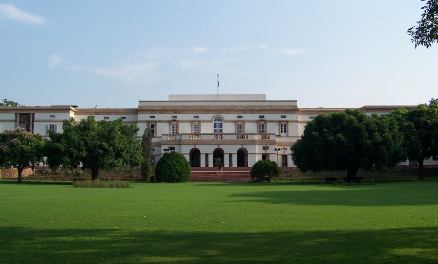
When he served as the first Prime Minister of independent India from 1947 until his death in 1964, Jawaharlal Nehru lived in Teen Murti Bhawan in New Delhi, a palatial residence originally built for the British Commander in Chief of India. Teen Murti Bhawan sits on a large landscaped plot due south of the president’s palace (Rashtrapati Bhawan), formerly the Viceroy’s House. A long circular drive leads from the compound gate to Teen Murti house itself. Behind the house is a formal garden planted with rose bushes. After Nehru’s death, the house was preserved as a memorial to the man and his times, the Nehru Memorial Museum and Library. Schoolchildren flock to the free museum, tramping through the big house’s empty corridors and taking in a show in Hindi or English at the planetarium on the grounds (built after Nehru’s death).

Behind and to the east of the house, tucked in among the trees, is a remarkable research institution, the library of the Nehru Memorial Museum and Library. Housed in a modern concrete building with dark wood paneling on the interior, the Nehru Library has an elite air, fitting for a place established in memory of wealthy, England-educated Nehru. The regular collection of the library is focused on modern India, and the Nehru Library is without a doubt one of the best places in India to study the late colonial and independence periods. In the back of the library, reached by its own stairway, there is also a small reading room for the library’s archival division, which is supposed to hold the world’s largest collection of manuscripts related to modern India.

The lobby of the library sometimes hosts public exhibitions, but the main stacks are only open to serious researchers, who have to apply for a membership and pay a nominal fee. (When I did some research for my dissertation at NMML two years ago, I paid Rs. 300 for a two-month membership. There are also options of a one-week membership for Rs. 100 and six months for Rs. 500.) Getting permission to access the archives requires its own application, with a letter of introduction from the researcher’s home institution and a form from the researcher’s diplomatic mission in India (for international scholars; I used a photocopy of a form I got for the National Archives of India).

The Nehru Library has open stacks, which is a rare treat in specialized research libraries. The archives, of course, are not open, and the holdings can only be accessed by filling out a request slip. Not all of the archival records are accessible even to legitimate scholars. The papers of Jawaharlal Nehru are only open to 1947. Nehru’s papers from his tenure as Prime Minister are off-limits because they are still classified. (The Indian government’s policy for declassification is not transparent. Even though Nehru has been dead for more than fifty years, his papers are kept out of public view because they theoretically still hold state secrets.) But scholars of modern India need not despair, because the papers of many other post-independence leaders are accessible.

When I did my research at NMML, I ran into two challenges that made my work there harder than I expected it to be. The first was just getting there. Teen Murti Bhawan is located in the sprawling neighborhoods of colonial bungalows on the south side of Rajpath in New Delhi, an area that is poorly served by the city’s metro. I rode the 604 or 620 city buses from Sansad Marg (still sometimes called by its English name Parliament Street) to Teen Murti Circle, but the street was frequently blocked by sit-down protests staged by one or another disaffected part of the population. When that happened, the bus would be routed down a different street, and I never did figure out where.

The other challenge was a result of my not understanding how government business works in India. The National Archives of India is closed for only a few holidays every year: Republic Day (January 26), Independence Day (August 15), Gandhi Jayanti (October 2), and the lunar festivals of Holi (February or March) and Diwali (October or November). NMML and most other offices are also closed on India’s many regular gazetted holidays, which are posted online on the official government calendar, but are not posted anywhere in the building itself. This was at least the case two years ago. I kept making the long trek to Teen Murti Bhawan only to find that the library was closed for a religious holiday celebrated by one of the minority communities. One day, the library was dark and empty for Mahavir Jayanti (Jainism), and the next it was closed for Good Friday (Christianity). If I had known to check for gazetted holidays, I could have planned accordingly and used my time better.

These challenges aside, researching at the Nehru Memorial Museum and Library was a rewarding experience. The private papers I read at NMML provided a human counterpoint to the formal, technical documents I found at the National Archives. The landscaped setting of Teen Murti Bhawan was a refreshing place to research. When I needed a break from manuscripts, I could go walking outside. I enjoyed spending a few weeks at the Nehru Memorial Museum and Library while researching my dissertation, and I hope I get the chance to return there for a future project.

jaisamand-lake-pan

Jaisamand, Mewar’s superlative lake

View of the ornamented backside of Jaisamand Dam.

View of the ornamented backside of Jaisamand Dam.

In southern Rajasthan, thirty miles south of the city of Udaipur, twenty square miles of the Aravalli Mountains have been flooded by the remarkable Jaisamand Lake, formed by the 1500-ft Jaisamand Dam. Tourist guidebooks frequently erroneously refer to Jaisamand as the second-largest artificial lake in Asia. This is far from the truth; in India alone, a half-dozen artificial lakes are much larger than Jaisamand. What is remarkable about Jaisamand is the combination of its size and its age. The lake was built in 1685 on behalf of Maharana Jai Singh of Mewar. Jaisamand holds the undisputed distinction of being the largest extant pre-modern artificial lake in India.

Of the numerous Rajput kingdoms in medieval western India, Mewar was the last to submit to the Mughal Empire. In 1568, Mewar lost its capital Chittaurgarh to the army of Akbar after a long and bloody siege, but a royal remnant escaped to found a new capital at Udaipur. The Mughals tried to defeat Mewar again at the epic Battle of Haldighati in 1576, but Maharana Pratap Singh escaped with his life and his kingdom. (Alas, Pratap’s horse Chetak succumbed to his injuries during the battle, but he has since become a local hero in his own right.) Finally, in 1615, after a series of battles, Maharana Amar Singh was forced to accede to the Mughal Empire. This was more than fifty years after Amber became the first Rajput state to join the empire.

After getting dragged into the Mughal Empire, Mewar could redirect some of its resources from militarization to infrastructural development. Jaisamand Lake was one of the public works projects undertaken in the post-accession period. The lake stored water from the Gomti River, for use in irrigation. It also provided a setting for palaces and royal hunting reserves.

Jaisamand Lake has changed a little since the late seventeenth century. The original dam was refurbished around 1960. During the refurbishment, the historic front face of the dam was covered by a characterless concrete facade. The crest and backside of the dam, though, retain their historical appearance. A series of white marble steps lead down to the water. There are six stone chhatris (domed pavilions), six carved marble elephants, and a temple, Shri Narbdeshwar Mahadev Jaisamand. Despite some graffiti on the elephants, and the usual litter, Jaisamand Dam remains a place of historical importance and real beauty.

The steps on the backside of Jaisamand Dam.

The steps on the backside of Jaisamand Dam.

One of the chhatris on Jaisamand Dam. The white mark underneath the chhatri indicates the level reached by a flood in 1973.

One of the chhatris on Jaisamand Dam. The white mark underneath the chhatri indicates the level reached by a flood in 1973.

Pigeons fly over Shri Narbdeshwar Mahadev Jaisamand Temple, located front and center on Jaisamand Dam.

Pigeons fly over Shri Narbdeshwar Mahadev Jaisamand Temple, located front and center on Jaisamand Dam.

The characterless concrete face of the refurbished Jaisamand Dam.

The characterless concrete face of the refurbished Jaisamand Dam.

Jaisamand is accessible from Udaipur by Banswara-bound bus from the main government bus terminal near Udaipol. The dam and the lake are just up the hill from Jaisamand town, where the bus stops. Boat rides are available from the dam, at Rs 600 per boat for a half-hour or Rs 1200 for the full hour. On a hill just above the dam, a ruined palace stands on forest department land. Visitors can get permission to climb up to the palace from the forest department office, with payment of a fee. I thought the rate for foreigners of Rs 300 was ridiculously steep – even without the additional Rs 900 camera fee – so I opted out of that experience.

Panoramic view from the Chandigarh Secretariat.

Report on the City Beautiful

The Legislative Assembly in Chandigarh, designed by Le Corbusier.

The Legislative Assembly in Chandigarh, designed by Le Corbusier.

I remember the first time I heard about Chandigarh, the planned capital of the Indian states of Punjab and Haryana. It was during my first sojourn in India, after I had already spent several months exploring the country. It was a long and boring Saturday afternoon, and I was looking at the Rough Guide to India. I came across the city map of Chandigarh, which has perfectly rectangular, uniformly-sized blocks. I thought: Huh? I was used to seeing Indian cities that had been laid out haphazardly, so how did Chandigarh get to be built on a grid?

As I learned later, Chandigarh was built after Partition to replace Lahore, the traditional capital of Punjab, which was now in Pakistan. (At this time, Punjab and Haryana were a single state.) Prime Minister Nehru was in favor of building a totally modern capital for Punjab, to represent India’s arrival on the world stage as a modern nation. The individual who gets most of the credit for designing Chandigarh was the Swiss-born architect and prophet of modernism Le Corbusier. In reality, Le Corbusier was not the sole creator of Chandigarh, as he modified a town plan worked out earlier by the American architect Albert Mayer. The first phase of Le Corbusier’s plan, which ended up getting built with some further modifications, called for twenty-nine numbered sectors separated by huge landscaped boulevards. The state government buildings are in the Capitol Complex in Sector 1, and the main commercial district is Sector 17. Northeast of the city, in Sector 6, is a large city park centered around Sukhna Lake, an artificial lake impounded by a long embankment.

The town plan of Chandigarh, as portrayed in the city museum.

The town plan of Chandigarh, as portrayed in the city museum.

Paddleboats on Sukhna Lake.

Paddleboats on Sukhna Lake.

Chandigarh has gained a certain notoriety for its unusual town plan. The scale of the city makes it impossible to get anywhere by walking. The population density is too low to support a metro, and the city buses run infrequently. More than anywhere else in India, the people of Chandigarh have to rely on private automobiles to get around their city. In fact, Chandigarh is the only place in India that has more registered motor vehicles than people. (This includes scooters and motorbikes as well as cars.) The shopping center at Sector 17 is so large and sparse that it is never crowded and bustling like the commercial districts of other Indian cities. James C. Scott devoted a couple of pages to Chandigarh in his seminal critique of authoritarian high-modernism, Seeing Like a State: How Certain Schemes to Improve the Human Condition Have Failed (1998). He included a black-and-white photo of Sector 17, which looks like a massive concrete wasteland with a few tiny human figures standing in it.

My attempt at recreating the photograph of Sector 17 in Scott's Seeing Like a State.

My attempt at recreating the photograph of Sector 17 in Scott’s Seeing Like a State.

Five years after first learning about Chandigarh, I have finally gotten a chance to visit the city. I could not draw any definitive conclusions about Chandigarh from a few short days there, but I did see enough to conclude that dire reports of the city’s poor planning and un-Indianness are exaggerated. While I do agree that it was foolish to make the city as big and spread-out as it is, it is still unmistakably an Indian city. Although private cars and motorbikes dominate the roads, there are also plenty of cycle rickshaws, autorickshaws, bicycles, and even horse carts. Sector 17 is a little bigger than it needs to be, but I feel that the austere photograph in Scott’s book misrepresents the place. It was likely taken early in the city’s life, before the place had had a chance to mature. In 2015, the shops around Sector 17 have brightly printed signs above them, like shops everywhere else in India. Far from being a concrete wasteland, the plaza in the middle of Sector 17 now has pipal trees and park benches in it.

A pipal tree in Sector 17, Chandigarh.

A pipal tree in Sector 17, Chandigarh.

Chandigarh is certainly unusual, but it is not exceptional in India. Planned towns in the Indian subcontinent date back to antiquity. Harappa and Mohenjo-Daro, two archaeological sites in present-day Pakistan, are the remains of two nearly identical cities built more than three thousand years ago. Although we know nothing about Harappan society, it is clear that they had a strong and centralized government that was able to enforce the town plan. Texts from later Indian antiquity describe the ideal city as a large square subdivided into square blocks, with the king’s palace in the central block. It is not clear whether such a city was actually constructed in antiquity, although the builders of Jaipur did follow the ancient guidelines when they laid out their city in the early eighteenth century.

The arrival of British colonists brought European-style town planning to India. Some Indian towns still have cantonment areas laid out in perfect grids for the British who once occupied them. Since independence, extensions of many existing Indian cities have been built on lines similar to Chandigarh. For example, Dwarka Sub-City in Delhi National Capital Territory was laid out by the Delhi Development Authority. (Other cities have similar agencies overseeing their expansions.) Dwarka is not built on a perfect grid, but it is built sector-by-sector with large streets separating the sectors. It does not seem to be a very efficient use of space. The Delhi Metro runs through Dwarka, but much of the sub-city is not convenient to the metro. The housing societies are built for people who own their own cars.

Apart from the scale, the most significant difference between Chandigarh and Dwarka is the underlying motive for construction. From start to finish, Chandigarh is infused with modernist ideology; it declares that India has arrived as a modern nation. Dwarka, on the other hand, is just a place for middle-class people to live.

Chandigarh's Open Hand Monument, designed by Le Corbusier but not constructed until 1985.

Chandigarh’s Open Hand Monument, designed by Le Corbusier but not constructed until 1985.

Powered by WordPress & Theme by Anders Norén